HOT TOPICS
SPOTLIGHT AGENCIES
Choked connectivity to Whitefield - solutions?
Written By silkboard - 14 July, 2011
Bangalore Whitefield BMTC Roads Citizen Reports Transportation public transport BPS
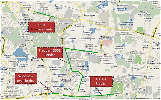
If you look back, or go ask city agencies, they would say that a lot has been done to improve connectivity to Whitefield. A six-lane railway overbridge at Marathahalli, 2006. A prominent Big-10 service (G-1), 2010. A once-every-5-minutes air conditioned bus service (335E), 2009. Road improvements (Varthur Road, Mahadevapura main road), since 2003.
And yet, here is some statistic for you.
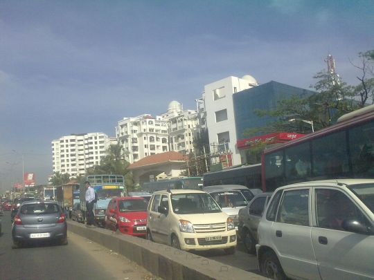
- In 2005 Dec, when Marathahalli Bridge was barely 2 lanes worth, It took 10-14 minutes to cross it at 9 am. It just looked a lot worse when you went through the stretch. Last week, time taken to cross it at 9.30 am has been 9-12 minutes.
- In 2006, time it took to go from Varthur Kodi to HAL Airport, despite all the airport rush used to be 20-25 minutes. Times I recorded were at 9 - 9.30 am, on Mondays and Tuesdays. Today, you would spend 30-35 minutes to do the same distance. 40-45 minutes if you do this on BMTC Bus.
- Using the Bus a lot for my commute gives me the opportunity to note commute times (something that I anyway need to do to collect data for BPS concept paper). My 6 kilometer commute has taken 20 minutes or more (least 19, max 32) over all days of last-3 weeks when done on car. And 25-40 when done on BMTC.
Alright enough of build up. The summary is that despite valid claims of investments in public transport, as well as roads (and pavements too!), average speed of movement during commute times is 15 km / hour. And this is the story when you go "out from" Whitefield to the Fringes of City. I am guessing that if I were doing the reverse, average effective speed would be no more than 12 km / hour.
Why? And what next? After a good start, is Whitefield area set to repeat the same choked-suburb story? To be continued.
COMMENTS

akauppi - 14 July, 2011 - 05:36
Not that it's really helping the situation, but... a report from New York:
What I like in your approach is measuring the times it takes to move. In order to make something better, data is needed. Of course it should be the city's job to track that data but if they don't, private citizens can. Especially with the use of smart phones, such collection could even be automated.
Meaning you'd have an "app" which you inform at the beginning of a trip and it measures the progress (or lack of) and pushes that to some website. If even some people do this over time, it'll add up to usable statistics of the city traffic as seen from i.e. buses.
Would this model work in current Bangalore? Do people have i.e. iPhones, Androids or other that can run such?
- Asko Kauppi
BM Design Oy
Helsinki, Finland
silkboard - 14 July, 2011 - 05:43
Thanks Asko. Reminds me that someone too asked how such data was collected for Bus Priority System work. No special apps on phone, nothing fancy at all. Easy way is to just take pictures from the phone at predefined spots and points of interest. Do it for a full week, and that's it. You get time (saved as photo's timestamp) and for later remeberance, the spot where you noted the time (in the photo!). Can sit anytime later at leisure to do the calculations.
We could do an Android accessible app to make it easy for many of us to uploading time data at one same place. Or to start simple, a basic form for people to fill in data from predefined spots (I was <here> at ___). Data really helps in doing anything next - advocacy, protests, planning, suggestions or whatever.
Data can be recorded using Google My Tracks
sanchitnis - 14 July, 2011 - 06:10
Hi,
We can use this applications which does exactly what was requested: Take records of timings, speed as well as upload on google spreadsheets for sharing with others.
My Tracks is an application for your AndroidTM phone that enables you to record GPS tracks and view live statistics – such as time, speed, distance, and elevation – while hiking, biking, running or participating in other outdoor activities. Once recorded, you can share your tracks, upload them to Google Spreadsheets and visualize them on Google My Maps.
Sanjay
akauppi - 14 July, 2011 - 07:21
I've got a friend startup here in Finland, planning to make bus usage in "developing economies" (starting in Latin America) easier and faster. They're called BusFaster. I love the idea and approach of making things cheap and simple.
What is their challenge imho is to find the right route into existing burocracies when it comes to public transport operation and planning. This will also shape what their actual business model will be.
If here are people wanting to keep Bangalore on their radar, you can take contact. Personally, I think if they can pull through a succesful demo in Lima applying the same in Bangalore would be no problem.
What do you think? :)
sanjayv - 14 July, 2011 - 15:34
Apparenly they squeezed some macro level pin the tail on the donkey style widening schemes & our BBMP uses that as a good excuse to ram thru band aid fixes.
Maybe the RMP can be much better. I do not know enough about this, but this seems to be the accepted wisdom. However, some plan is better than no plan. Since the Whitefield area is now an agglomoration of tech parks and housing developments with no structure or plan, what I saw in a portion of the RMP made sense to me.
PRAJA.IN COMMENT GUIDELINES
Posting Guidelines apply for comments as well. No foul language, hate mongering or personal attacks. If criticizing third person or an authority, you must be fact based, as constructive as possible, and use gentle words. Avoid going off-topic no matter how nice your comment is. Moderators reserve the right to either edit or simply delete comments that don't meet these guidelines. If you are nice enough to realize you violated the guidelines, please save Moderators some time by editing and fixing yourself. Thanks!