HOT TOPICS
SPOTLIGHT AGENCIES
BMRCL Ph II DPR route?
Written By srinidhi - 11 March, 2010
Bangalore Namma Metro Analysis itpl Transportation public transport BMRCL Metro Rail Phase2
Naveen presented a good summary of his meeting with BMRCL
One thing that came of that was the DPR for the phase II was in the final stages and would be out soon..there are already questions on
- What is the level of public participation in the proposed routes
- Information on nputs that went to decide the routes by DMRCL.
- Any traffic studies that were used
However the route based on the soil testing done is as below:
Kattariguppe - ITPL route
Kattariguppe - PES college(srinagar) - Basavanagudi(crosses reach 4) - SJP park - Corporation bldg - Richmond rd - Vellara jn - Domlur - Old Airport - SuranjanDas rd - Byappanahalli - KR puram RS - Mahadevpura - ITPL
IIMB - Nagavara route
IIMB - Jayadeva Hospital - Dairy circle - Vellara Jn - Shivajinagar - Tannery rd - Nagavara
I have tried to mark the ph II route on a bangalore map..
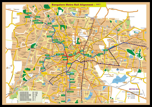
Is this a fairly accurate? and what do we feel of this plan itself?
COMMENTS

gvivek2004 - 5 February, 2012 - 13:06
Hello All,
Iam trying to purchase a property near old madras road OMR in paylayout about 50 metres from old madras road (OMR). I got news that phase 2 will start from Baiyappanahalli to Whitefield.
Iam worried if metro phase2 will cut through. I tried to find information everywhere, but could find little.
With the images given here, im not able to conclude. Kindly help where can i get this info.
Best Regards/ vivek
Metro Phase 2 at 5th main, 5th block, 40th Cross, Jayanagar
Sathya kumar - 14 June, 2012 - 07:24
Hello All,
I am new here and trying to get information on the status of Metro alignment turning left at Rajalaxmi Kalyana Mantap Junction leading to Silk board.
I am one of the residents among the 16 houses effected under thier proposed alignment, cutting through my house (4th house from the corner. From the information we have as on yesterday is that six houses on 5th main road, 4-6 houses on the 6th ain road and 2-3 houses on the 46th cross is confirmed to be part of their plan.
Markings in blue color with Pier no has been done all through the park leading to my property . Unfortunatly no confirmation from BMRCL as yet, apart from survey engineers orally confirming that its been finalized.
We (16 residents) have submitted a representative letter Dt.17th May 2012 to the Managing Director seeking confirmation with possible multiple options which can save all the houses, sadly no response.
Seek advice on how do we take this forward, either to get required confirmation or to seek information on possible alternatives that can be considered.
Most of the residents are retired and staying here from 40-50 years with joint familites (2-3 families) under one roof. Componsation I hear is on SR guidance value, all of us are confused and worried as to what will happen.
Requesting people in this forum to advice on how do we take this forward towards saving our homes, planned to gather all the affected residents on the 17th Sunday to chalk out our plan of action.
- RTI for required information,
- Sound advocate who can represent all of us,
- Follow up second letter of representation to the MD, BMRCL to look into possible options leading to saving our homes.
Eagerly look forward for comments / advice
Have a nice day.
Warm Regards
SK
srinidhi - 16 June, 2012 - 00:57
As far as how BMRCL has taken up the metro work since the begining is that the DPR done by Delhi Metro is their bible and they will do everything needed to stick to that..ofcourse small chages like stations additions have been done at the behest of other forces..
I am not sure you can get legal advice here on praja and BMRCL doesnt respond to RTI's..so think the best way is to approach the state govt..meet Ananth Kumar or someone sitting high to help..
One option is to get them going underground for the stretch from Rajlakshmi to Silk Board..guess that will help in lot manyways, including sparing many homes to be brought down..and crossing over edifices like Jayadeva flyover..
The other option is do the jaipur way..having a road carriage way along with the metro line..like below:

metro phase2 alignment near pai layout
gvivek2004 - 31 January, 2012 - 03:30
I have shortlisted to buy a property in pai layout which is just two streets away and hardly 50 m -100 m from OMR. After seeing the alignment iam confused if the metro will cut across the property. I thought the alignment will follow the rail road which cuts the old madras road and be aligned to it (or) it will continue in the same side as byappanahalli and cross the lake to reach kr puram station...but the alignment shows it is not aligned to old madras road, but it will cut through pai layout and will reach jyothipuram station.
If the alignment is made more visible enough (or) accurate enough, it will help me decide whether to buy or not to buy a flat in pai layout.
If i send a mail to BMRC, will they share the official alignment with me? Kindly help.
PRAJA.IN COMMENT GUIDELINES
Posting Guidelines apply for comments as well. No foul language, hate mongering or personal attacks. If criticizing third person or an authority, you must be fact based, as constructive as possible, and use gentle words. Avoid going off-topic no matter how nice your comment is. Moderators reserve the right to either edit or simply delete comments that don't meet these guidelines. If you are nice enough to realize you violated the guidelines, please save Moderators some time by editing and fixing yourself. Thanks!