HOT TOPICS
SPOTLIGHT AGENCIES
Bangalore Elevated Tollway
Written By tsubba - 21 July, 2007
The longest National Highway in the country, NH7, connecting Varanasi and Kanyakumari, is famous neither for mythology surrounding those two towns, nor for the lively towns it connects. Instead, the highway’s claim to national and international fame is a 9km jam on a stretch known as the Hosur Road in namma bengaLooru.
To ease the congestion between Silkboard Junction and Electronics City on Hosur Road, the NHAI commissioned the Bangalore Elevated Tollway Limited (BETL) in early 2006. BETL is a special purpose vehicle created by the joint venture consortium of Maytas Infra , Nagarjuna Construction Company Ltd. (NCC) and Soma Enterprises Limited (SEL), to enhance the capacity of the road by constructing a new four-lane elevated tollway. (Hence the name.)
Apart from this, improvements to the "at grade" part include making it a 3x3 lane highway and adding 2 lane access roads over the storm water drains on both sides of it. Six underpasses for pedestrians along the 9 km stretch are also planned since the highway median prohibits pedestrian crossing.
While not much is known about how the road will look at the Silkboard end, Soma Enterprises has published renders of how the road is to look at the Electronic Eity end. (Click on the images for larger views**)
Shown below is the traffic flow diagram at the Electronics City end of the tollway based on these illustrations. The thick lines correspond to tollway(T/W) lanes, the thin lines correspond to highway(H/W) lanes, the black lanes are elevated, and the gray to black lanes are the ramps.
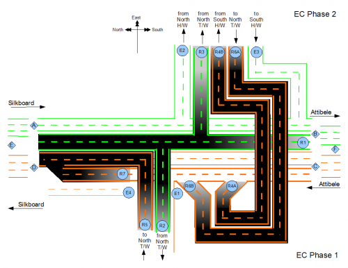
The flow to and from the tollway itself is easy to understand and appears to have been designed to flow smoothly.
But on the at grade highway, curiously, there seems to be no direct way for somebody from Silkboard or the BMIC PRR to get to Phase1. One has to either go all the way to point <F> further South of the interchange, make a U-turn, head North again and then take exit E1* to Phase1. Or they have to take E2 on the highway, make U somewhere within Phase2 and then take ramps R6A-R6B before taking E1.
Similarly, it appears that for somebody from the EC Phase1 to take the highway South towards Attibele, or to go to EC Phase2, they have to initially head North on the highway, and then take a U-turn at <E>. <E> is also perhaps the point where you take a turn to get on to the BMIC PRR towards Mysore road. This could be a major bottle neck, because all this traffic is entering the highway from left and has to move to the right, to make the U-turn.
Around the interchange, the flow on the "at grade" highway also does not appear to be smooth. Around the interchange, the highway trickles down to 2 lanes in each direction. The flow from Silkboard and from BMIC PRR to either campuses of EC faces a 3 lanes to 2 lanes pinch at congestion point <A>. At <D> again, there is a 4 lane to 3 lane pinch: 2 lanes from EC Phase1 merge with 2 lanes carrying highway and EC Phase2 traffic heading North on the highway. At <B>, the 2 tollway lanes conflict with 2 highway lanes heading South. Only <C> is a 3 lane to 4 lane split that separates traffic towards EC and tollway to Silkboard from the remaining highway traffic headed North and should be easy.
Irrespective of which direction you are headed, if you are talking the at-grade highway, you are in for atleast 3 pinch points. Considering that the Hosur Road consistently clocks a massive 1.2 lakh PCUs/day, these pinches(including u-turns at <E> and <F> ) could be significant.
* E1,E2, R1 R2 <A> etc., are names introduced here to discuss the flow. They are not thus named by BETL.
** Capture Credits: indiansunite @ SSC
Also read Future of Silkboard Junction for a take on the other end of the tollway.
COMMENTS

Vijay - 21 July, 2007 - 05:44
When is this slated to complete?
There must be many more bottlenecks on NH7 in Namma Bengalooru...
tsubba - 21 July, 2007 - 05:49
Vijay - 21 July, 2007 - 05:55
I will keep my fingers crossed. Each Flyover seems to move the traffic to the next junction. I hope the elevated road does not move the congestion to Hosur ;-)
I also hope theres no pending land acquisitions from our mannina magas.. I dont know if you have been on the NICE road connecting Mysore Road to Kanakapura Road... its great until the last 100 metres (at the K'pura junction) where the road goes from Great to Gross...
tsubba - 21 July, 2007 - 20:13
PRAJA.IN COMMENT GUIDELINES
Posting Guidelines apply for comments as well. No foul language, hate mongering or personal attacks. If criticizing third person or an authority, you must be fact based, as constructive as possible, and use gentle words. Avoid going off-topic no matter how nice your comment is. Moderators reserve the right to either edit or simply delete comments that don't meet these guidelines. If you are nice enough to realize you violated the guidelines, please save Moderators some time by editing and fixing yourself. Thanks!