HOT TOPICS
SPOTLIGHT AGENCIES
Rethinking road-widening - Tunnels?
Written By Transmogrifier - 22 June, 2010
Bangalore Corridors NH7 Road widening Mysore Road Analysis Signal Free Transportation Infrastructure Flyovers and underpasses NH4
One of the core infrastructural issues we are facing is an inability of our arterial roads and highways to provide rapid cross-town access. Globally, city and highway planners recognize and create different infrastructure for highways and city roads. See Dr. Joglekar’s posts here for a succinct description of this problem plaguing most Indian cities. A simple schematic (full size image here)and an inventory of city highways reveals the problem.
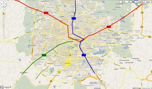
Thru Highways:
- NH7 (in blue)
- NH4 (in red)
Terminal Highways:
- NH-209 (in yellow)
- SH-17 (in green)
While the ORR and the planned PRR attempt to relieve through-traffic, these highways ironically remain some of the fastest cross-town routes. Recognizing this, infrastructural planners have expanded/widened roads leading into the city where land was available and have built (BETL, Mysore Rd flyover), are building (Nelamangala expressway) or planning to build (Balabrooie-Hebbal) long flyovers to ‘jump’ the bottlenecks. As we all know though, these just move the bottlenecks. And so, the ever-unpopular (and time-consuming) appropriation of massive amounts of land and road-widening is being touted as the panacea. There might be another way though.
An alternative
One option might involve reconnecting NH-4 and NH-7 using a belowground access-controlled (NOT signal-free) highway that cuts through the city and ensuring that NH-209 and SH-17 don’t ‘dump’ traffic in the middle of the city (full size image here).
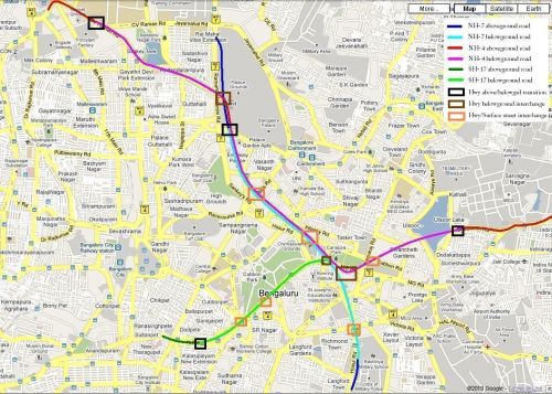
Specifically:
- Travelling south, NH-7 would move completely off the existing Bellary Rd after the Mekhri circle underpass moving onto Palace ground property (that might be available). At Cauvery theatre, it would join an emerging NH-4 and then ‘dive’ underground just before Palace Road ‘emerging’ near (or after) the Military school on Hosur Road.
- Traveling east, NH-4 would go underground near the IISc Gymkhana ground (potentially before the MS Ramaiah Rd intersection). It would emerge near Cauvery theatre (on Bellary Rd) and join NH-7. After ‘re-submerging’ near Palace Rd, it would travel along with NH-7 branching off (belowground) to emerge near the Bhaskaran Rd/Kensington Rd intersection
- Traveling north, SH-17 would go belowground at the foot of the Sirsi Circle flyover and join NH-4/NH-7 underground.
- NH-209 would terminate at ORR leaving users the option of using SH-17 or NH-7 for a cross-town commute.
The project would function best if expressway design standards are consistently adhered to. All project roads should maintain a constant width (preferably 4 lanes + 2 emergency lanes) widening to 6 lanes only in sections where highways combine (e.g. NH-4 and NH-7). A limited number of surface exits could enable rapid access to different points in the city (K.G. Road, Kanteerava stadium, Millers Road/Vidhana Souda, HSRL terminal/M.G. Rd, Kamaraj Rd, Richmond Rd etc). Further appropriately designed interchanges (dark brown squares in pic) would be required to connect highways underground.
Pros, cons and disclaimers:
- Cost: Similar projects across the world have cost anything from Rs 280 crore (for Sydney’s 2-lane Cross City tunnel to a staggering 66,000 crore (for Boston’s 10-lane Big Dig. However, BBMP’s existing road-widening plan on 6 corridors already calls for an investment of 597 crores.
- Time: Similar projects have taken anything from 2 years (Cross City tunnel) to 22 years (Boston’s Big Dig)
- With adequate planning, inconvenience to road users can be minimized with tunneling work starting in areas where no current roads exist (e.g. Palace Grounds, Ulsoor Lake, SJ Park) emerging onto the surface nearer the completion date. After cross-town connections are complete, exits to surface streets (e.g. K.G. Rd, M.G. Rd) can be added on.
- Other arterial corridors can (in some cases) be redesigned to filter onto ‘reconnected’ highways. For example, Old-Airport Road can be connected to NH-4 using Suranjan Das Road.
- This project would not address existing bottlenecks outside the project area (e.g., the Bennigannahalli bottleneck on Old Madras Rd). However, using a consistent road-width 4 (travel) +2 (emergency) lanes and strict access-control throughout would make the highways effective travel corridors.
- The project does not address surface streets or public transportation. However by reducing current traffic loads on surface streets, roads can be engineered to maintain a consistent (4-6 lane) width, turning refuges and better pedestrian infrastructure. Existing one-ways can be reverted to two-way traffic or provide contra-flow bus lanes.
These ideas are not new to city planners as cities the world over have demonstrated the use of this technology. Will it work for us?
(Image courtesy: Wikipedia)
transmog
COMMENTS

idontspam - 25 June, 2010 - 04:58
Good analysis, Though I dont agree with the pink line connection to NH4 West. There is already a connection via CV Raman Road further ahead. So you get the 2 lanes on your pink corridor with signals at bashyam circle and junctions @ 18 cross and Circle mariyamma temple and you get another 2 lanes via CV Raman road with just New BEL road junction in between. Both meet at IISc jn. SO on surface there is 4 lanes each way available already making it a 8 lane corridor. The idiots at BBMP are trying to expand it to what? 10 lanes? What for? all they need is sensors on the road and some electronic (Cheap LED ones will do) display boards to measure traffic and direct people accordingly. Of course put some lane marking with physical barriers for turn lanes appropriately.
OTOH. If you are planning subsurface corridor it need not follow any of these roads but will only need exits & entry ramps on them. Lets mark out the actual corridor, where it will cross the other mass transit infrastructures, where the exits & entries need to be. If this is done well we can easily work out the total kms and hence the costing. Start a project I will join.
srinidhi - 25 June, 2010 - 06:05
Bringing highways into town thru underground corridor is good...probably this chimes with the govts earlier plan to build elevated corridors within then city..however think duddu will be the biggest criteria, more so with the underground setup!
We know of the recent such projects in the Boston BigDig..it costed them 15 Billion Dollars..and ppl are not sure even now if they will turn profitable anytime soon!
idontspam - 25 June, 2010 - 08:27
.however think duddu will be the biggest criteria, more so with the underground setup!
Nothing will get cheaper anymore. Funding can be arranged if it is an intelligent plan. It cant be a joke like flyovers BBMP announces from time to time. Lets not jump to duddu before working out the solution. Big dig wasnt paid for in cash. Leverage is available in the form of bonds, loans, private participation. If all the politicians black money is unearthed this project can be paid for many times over. So if govt runs out of money we will tell them to dig into their swiss bank accounts. We could petition Reddy's to fund.
I beg to god BBMP doesnt get to build it, it will turn out like the underpass they build, stinking, water logged, roof peeling off and permanantly locked.
Naveen - 25 June, 2010 - 13:34
Apart from the huge capital needed for building tunnels, they also need to be managed & maintained well. What we see in our cities is nothing but examples of dirty, broken down pedestrian underpasses, though these are merely some 40 mtrs in length, except for the one at city railway stn - even this may be short of a couple of hundred mtrs long.
The milan subway in Mumbai (Santacruz) floods routinely during monsoon - & this has been the state of affairs there for over two decades now, despite repeated occurrences.
How can we expect our rickety systems to cope with tunnels that are several kms long ? Even our flyovers have started collecting water during showers (like BETL) !
And what about lighting, ventilation, signage ? I think it's better not to think of road tunnels !!
The only exception is rail tunnels, which are managed fairly well, though lighting & ventilation isn't so much of a necessity there.
idontspam - 25 June, 2010 - 17:43
Management? Maintenance? What is that? There is swiss challenge, swedish challenge etc for making money on infrastructure construction. For maintenance there is only pourakarmika challenge.
PRAJA.IN COMMENT GUIDELINES
Posting Guidelines apply for comments as well. No foul language, hate mongering or personal attacks. If criticizing third person or an authority, you must be fact based, as constructive as possible, and use gentle words. Avoid going off-topic no matter how nice your comment is. Moderators reserve the right to either edit or simply delete comments that don't meet these guidelines. If you are nice enough to realize you violated the guidelines, please save Moderators some time by editing and fixing yourself. Thanks!