HOT TOPICS
SPOTLIGHT AGENCIES
Bengaluru Mono Rail - proposal details
Written By idontspam - 11 February, 2009
Bangalore monorail Analysis alignment Transportation public transport Mobilicity Metro Rail
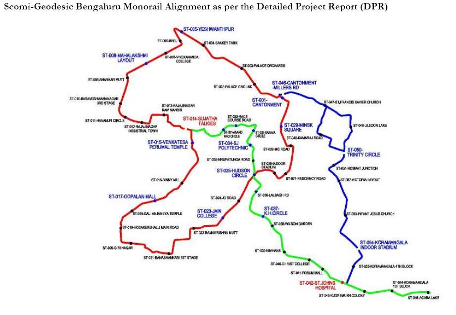
There is a proposal for runing Mono Rail in Bangalore by SCOMI-Geodesic consortium which is proposed to be awarded using the swiss-challenge method. As per initial high level information sent to Praja the consortium is proposing to build monorail along the three corridors.
A total of 54 stations have been proposed. The Red Line will have twenty nine stations. Seventeen stations have been proposed on the Green Line. Eleven stations have been proposed on the Blue Line. All the stations would be elevated stations. The stations near Sujatha Talkies Rajajinagar and at Hudson Circle will serve as interchange stations between the Red and Green Lines. The station near St. John’s Hospital will serve as an interchange station between the Green & Blue Lines.
Three depots are envisaged for the three corridors. To have connectivity with other modes of transport and to ensure an integrated system with other modes, ancillary structures like structural steel Linkways, Skywalks, are planned

See attachment for the route map and station list
COMMENTS

Vasanth - 16 April, 2012 - 17:54
Just was going through Mumbai Monorail videos on Youtube. Sharing the same
http://www.youtube.com/watch?feature=player_detailpage&v=WYtkGRTOmtM..
http://www.youtube.com/watch?feature=player_detailpage&v=Gs2EzWJk6So
http://www.youtube.com/watch?v=By0m2oepFA4
http://www.youtube.com/watch?feature=player_detailpage&v=UJrRriXsFYo
Will Mono ever come to Bengaluru?

Soil testing for BARL is under progress in JP Nagar (ring rd) & elsewhere. I think Bangalore will not get monorail, but there may be an elevated light rail, first route on Magadi rd & the western crescent of ORR (ie. JP Nagar to Hebbal via Kanakapura rd, Mysore rd, Magadi rd & Tumkur rd), as had been recommended by Capita Symonds, UK.
See this comment
Also, Report in Deccan Chronicle

Monorail Ph.1 - Jaraganahalli to Cant.
Naveen - 18 April, 2012 - 03:58
The corridor between Jaraganahalli along Kanakapura Road and Cantonment, which is part of the first phase of the Monorail project, will soon be implemented with the authorities undertaking soil testing along the project route.

Mono: JPNgr ORR-BTM 29th Main ?
Naveen - 19 April, 2012 - 10:38
201R goes along Marenahalli road, which is the same as one of the Metro routes in ph-2. Since mono routes are not going to duplicate any Metro routes (over long lengths), I think it may be aligned along JP Nagar ORR & BTM 29th Main. Will have to wait for the chosen route plan to know for sure.

srinidhi - 1 July, 2011 - 08:49
The 60-km Monorail project is aimed at decongestion of Bangalore Central Business District (CBD) and connects Railway and Metro stations, TTMCs, schools, colleges, hospitals, etc.
The four-phase project begins with a 16-km Green Line connecting Majestic and Agara Lake. It will serve as a feeder to Bangalore Metro creating additional transit capacity.
http://www.deccanherald.com/content/172308/monorail-project-mou-inked-financial.html
Still fail to understand the feeder nature of the Agara - Majestic line..I understand feeders as connecting to the closest metro line..but getting it all the way to Majestic doesnt sound right..
Also the govt needs to be very careful on the ticket pricing strategy..the earlier Scomi plan was costing way too much..it should not end up like NICE road..where they are charing more than 3Rs per KM instead of 1 Rs per KM which is a norm elsewhere!
PRAJA.IN COMMENT GUIDELINES
Posting Guidelines apply for comments as well. No foul language, hate mongering or personal attacks. If criticizing third person or an authority, you must be fact based, as constructive as possible, and use gentle words. Avoid going off-topic no matter how nice your comment is. Moderators reserve the right to either edit or simply delete comments that don't meet these guidelines. If you are nice enough to realize you violated the guidelines, please save Moderators some time by editing and fixing yourself. Thanks!


